
RTK GPS for Excavators: When Precision Reduces Rework and Project Cost
Does RTK GPS Guidance Actually Pay Off on Excavator Projects? Yes, when grade accuracy, dredging depth, rework, survey time, or underwater...

Real-time Kinematic (RTK) GPS is a system that provides precise location information. It is used in many industries, including the excavation industry. The excavation industry is a large and essential part of the construction industry. It includes digging holes and trenches for new buildings, roads, water lines, sewers, and other infrastructure projects.
The excavators must be precise when digging to avoid damaging existing buildings or infrastructure. To ensure this precision, excavators generally use RTK GPS systems to ensure their machines stay on course and do not damage anything else along the way.

RTK GPS stands for Real-Time Kinematic GPS, a global positioning system that uses several satellites to determine the device’s exact location. It can be used in many different ways. In the excavation industry, RTK GPS can help you with:
RTK GPS uses a base station that broadcasts its location to the RTK receiver, then compares its position to the base station and calculates an error value.
The error value is used to adjust the location coordinates of both the base station and the RTK receiver until they match precisely. At this point, you have real-time kinematic GPS readings that are accurate within centimeters.
An RTK GPS uses a base station and a rover to calculate the distance between the two. The former has an antenna that sends signals, and the latter receives them. The rover then calculates the time it takes for those signals to reach it and sends that information back to the base station.
For this process to work correctly, both devices must be set up on a level surface with no obstructions. Once set up together, they can calculate their positions in real-time—no matter where they go within their line-of-sight range (typically around 20 meters).
Specifically, real-time kinematic GPS uses differential correction to help a GPS receiver get precise and accurate location measurements. This is done by comparing one satellite’s location to another’s, which can help provide more specific information about your position. This process uses a reference station that has its own GPS receiver. The reference station takes measurements from satellites visible to both its receiver and your receiver.
The reference station then sends the information gathered from those satellites (known as differential corrections) back to your receiver in real-time. This process allows for much more accurate measurement of your position than traditional static GPS methods would achieve.
There are many benefits to using RTK GPS in the excavation industry. These include:
RTK GPS offers highly accurate positioning data when compared to traditional GPS systems. Standard GPS can only provide a few meters; RTK may provide accuracy within centimeters or less. Its accuracy is within 6 mm of the actual position. This means it can be used in areas with high precision requirements, such as when working on a bridge.
RTK is faster than traditional navigation methods because it does not require manual input from the user; this makes it easier for workers who need to move quickly while onsite. It provides real-time positioning and distance measurement. This allows you to know where your equipment is at all times, which reduces the risk of accidents and saves time by allowing you to work more efficiently.
Traditional GPS systems rely heavily on satellites. If there are problems with the satellites themselves or the connection between them and your device, you might experience errors in positioning data or even lose service entirely.
An RTK system does not have these issues because it does not rely on satellite connections. It uses ground-based stations instead of satellites for its calculations, making it more reliable than traditional systems.
This is especially useful in cases with interference from clouds or other factors that could interfere with the satellite.

Real-time kinematic GPS is available in many forms and can be used for many different purposes. The following are some of the ways people in the field of excavation use RTK GPS:
Excavators use RTK GPS to ensure they do not dig into an existing utility line or underground structure. This helps prevent damage to property and injury to workers.
Excavators can use RTK GPS to monitor their equipment remotely and ensure it’s working correctly before starting a job. This helps prevent damage from occurring to expensive equipment and saves time and money by avoiding unnecessary repairs or replacements.
RTK GPS also helps excavators avoid hitting utilities buried beneath the surface by providing an accurate location of where those utilities are located. This means that if an excavator hits a utility line while digging, they will know exactly where it’s situated so they can call for help or start repairing it immediately.
Excavators can use RTK GPS to control their work sites and ensure everything runs smoothly throughout construction projects. This ensures that projects stay on schedule, which saves money for both companies and individuals who hire contractors for construction jobs such as these.
In surveying, RTK GPS technology provides highly accurate geodetic measurements that can be used to precisely locate underground utilities and other essential features.
Choosing the suitable RTK GPS for your projects is an important decision and one that we don’t take lightly. We believe in providing our customers with the best possible service, which means helping them make informed decisions about their purchases. Here are some factors to consider when choosing an RTK GPS for your project:

RTK GPS has revolutionized the excavation industry in recent years. Using this technology to accurately and efficiently survey underground utilities is now possible, which can save time, money, and lives.
The benefits of RTK GPS are numerous. It can be used to determine a precise location in real time. It is accurate to within a few centimeters. It also reduces the need for expensive laser scanners or ground penetrating radar. Furthermore, it can be used by untrained personnel and only needs one base station per 100 square kilometers.
The future looks bright for RTK GPS users in the excavating industry. As more companies adopt this technology, they will realize its many advantages over traditional surveying methods.
Get in touch with us now!
Does RTK GPS Guidance Actually Pay Off on Excavator Projects? Yes, when grade accuracy, dredging depth, rework, survey time, or underwater...
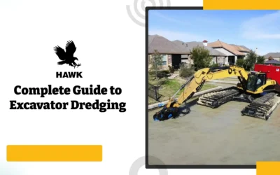
What Is Excavator Dredging? Excavator dredging is the process of using a hydraulic excavator equipped with a pump attachment to remove and transport...
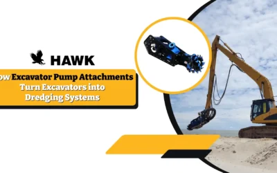
Excavator pump attachments turn standard excavators into dredging systems by using the machine’s hydraulic power to drive a submersible slurry pump....