Complete Guide to Excavator Dredging
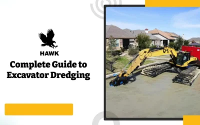
What Is Excavator Dredging? Excavator dredging is the process of using a hydraulic excavator equipped with a pump attachment to remove and transport...


Yes, when grade accuracy, dredging depth, rework, survey time, or underwater visibility directly affects the project outcome.
RTK GPS guidance for excavators is most valuable when operators need real-time bucket or attachment position, especially in dredging, excavation, grading, and hidden-location work where visual references are limited. On projects involving precision dredging, structural excavation, earthworks, or underwater digging, RTK GPS can help reduce rework, improve grade awareness, and give operators better visibility into where the bucket, dredge pump, clamshell, or hydraulic attachment is working.
RTK GPS does not automatically pay off on every project. The return depends on project tolerances, site conditions, correction signal reliability, operator training, machine setup, and how often precision work is performed. This article explains how RTK GPS systems work on excavators, where they deliver value, and what buyers should evaluate before selecting a system.
Grade and elevation errors on excavator projects rarely show up as one large failure. More often, they accumulate as small deviations that eventually create rework, schedule delays, material waste, and project disputes.
On a typical grading or excavation project, common cost drivers include:
On dredging projects, the challenge is even greater because operators often cannot see the bucket, dredge pump, clamshell, or cut surface. Depth gauges and visual references may be unreliable in turbid water, swift currents, low-visibility areas, or uneven underwater terrain.
Over-dredging can increase disposal costs, create compliance issues, and remove more material than necessary. Under-dredging can fail project specifications and require costly remobilization. In these applications, real-time positioning helps operators work with more confidence and reduces the guesswork that often creates rework.
RTK GPS guidance addresses these problems by giving the operator continuous position and elevation feedback. Instead of relying only on periodic manual surveys, stakes, visual judgment, or dead reckoning, the operator can see where the machine or attachment is working in real time.

RTK GPS stands for Real-Time Kinematic Global Positioning System. It is a survey-grade positioning method that improves standard GPS accuracy by using correction data from a fixed base station or RTK network. Standard GPS may only provide meter-level accuracy, while RTK correction can support centimeter-level positioning when properly configured.
On an excavator, an RTK GPS system typically combines satellite positioning, correction data, machine sensors, and software to calculate the real-time position of the bucket or attachment.
A typical excavator RTK GPS setup may include:
The system uses machine position and attachment geometry to help determine where the bucket tip, suction head, dredge pump, clamshell, or hydraulic attachment is located. The operator can then use that information to work closer to target grade, dredging depth, or excavation limits.
For dredging and underwater excavation, this is especially useful because the operator may not be able to see the attachment once it is below the water surface.
Buyers should be careful not to confuse RTK GPS guidance with full hydraulic machine control.
RTK GPS guidance shows the operator the position of the machine, bucket, or attachment so they can make better decisions during excavation or dredging. Full machine control can involve deeper hydraulic integration where the system assists or controls certain movements.
For many dredging and excavator-based applications, RTK GPS guidance is the practical starting point because the operator remains in control while receiving real-time position information.
System Type | Typical Accuracy | Best Application | Limitations |
Basic GPS Guidance | Lower than RTK | Rough grading, general location tracking, large earthworks | May not be accurate enough for precision grading or dredging |
RTK GPS Guidance | Centimeter-level positioning when properly configured | Precision dredging, grading, excavation, underwater attachment tracking | Requires reliable correction signal, calibration, and site setup |
Full Machine Control | Application-dependent | Fine grading and automated earthworks applications | Higher complexity and may require hydraulic integration |
For HAWKVision, the safest positioning is to describe it as an RTK GPS dredge and dig positioning system designed to help operators track excavator attachments, buckets, dredge pumps, clamshells, and hydraulic tools in real time. Any claims around full machine-control automation should be confirmed separately before publishing.

RTK GPS systems are designed to provide survey-grade positioning with centimeter-level accuracy when properly configured. HAWK’s public materials state that HAWKVision RTK GPS provides real-time tracking of dredging equipment, precise position information, and centimeter accuracy for dredging and excavation projects.
Actual field accuracy depends on several factors, including:
For this reason, RTK GPS should be described as a high-precision positioning system, but not as a guarantee of identical accuracy in every environment. Proper setup, integration, and calibration matter.

RTK GPS performs best on sites with a clear view of the sky and reliable correction signal access. Open dredging sites, excavation zones, mine ponds, waterways, and large earthwork areas are often better suited to RTK GPS than confined areas with heavy signal obstruction.
Projects near tall structures, bridges, dense trees, steep terrain, or urban obstructions may experience reduced signal reliability. In these environments, buyers should evaluate whether the correction source, base station location, or RTK network can support the required accuracy across the entire work area.
RTK GPS guidance makes the most sense when the cost of being wrong is high.
Examples include:
If the project only requires rough excavation, RTK GPS may not be necessary. If the project requires precision, documentation, or reduced rework, RTK GPS may provide meaningful value.
For dredging projects, RTK GPS guidance can be especially valuable because the operator often works below the water surface without direct visibility.
Important dredging considerations include:
HAWKVision is publicly positioned for hydraulic dredging, mechanical dredging, marine dredging from land or barge, excavation, buckets, dredge pumps, clamshells, and hydraulic attachments. That makes the system a strong fit for projects where the operator needs to know the real-time location of the working attachment.
RTK accuracy depends on reliable correction data. The right correction source depends on the site, available infrastructure, distance from reference points, and communication reliability.
Correction Source | Pros | Cons |
Local Base Station | Works in remote areas, does not depend on outside networks, provides a fixed reference point | Requires setup, placement, and verification |
RTK Network | Can reduce the need for a dedicated local base station, useful where network coverage is strong | Requires network availability and communication reliability |
Radio, Cellular, or WiFi-Based Correction Transmission | Allows real-time correction delivery depending on site setup | Reliability depends on distance, signal strength, terrain, and interference |
HAWK’s public page notes that the system uses a base station as a fixed grounding point and can also be integrated into an RTK network for broader coverage.
The purchase price of an RTK GPS system is only part of the evaluation. Buyers should also consider:
RTK GPS guidance is usually easier to justify for contractors and operators who perform repeated precision dredging, grading, or excavation work. The more often precision matters, the more value the system can provide over time.
System Type | Typical Use | Best Fit | Limitations |
Basic GPS Guidance | General location awareness and rough machine positioning | Large sites where rough positioning is acceptable | Not ideal for precision grading, underwater dredging, or tight elevation control |
RTK GPS Guidance | Real-time bucket or attachment position tracking | Precision dredging, excavation, grading, and hidden-location work | Requires correction data, calibration, and reliable site conditions |
Robotic Total Station or Optical Layout | High-accuracy structural work or locations with GPS limitations | Projects with tight tolerances and line-of-sight access | May be slower or less practical across large or changing work areas |
Full Machine Control | Automated or assisted grading workflows | Certain fine-grading and earthmoving applications | More complex and may require hydraulic integration |
No single system is right for every application. The right choice depends on project tolerances, site conditions, machine configuration, attachment type, budget, and how often the system will be used.

Precision Dredging: RTK GPS guidance helps operators track underwater dredging position when the bucket, dredge pump, clamshell, or suction head is not visible. This can be useful for channel maintenance, pond dredging, environmental sediment removal, marine dredging, and hydraulic or mechanical dredging projects.
Excavator-Based Dredging: For excavators working from land, barges, or amphibious platforms, RTK GPS can help operators track attachment location and reduce reliance on visual judgment alone.
Foundation and Structural Excavation: When excavation depth and grade accuracy matter, RTK guidance can help reduce rework and improve operator awareness during cut-to-grade work.
Bulk Earthworks and Site Grading: RTK GPS can help operators work more efficiently across large areas where repeated survey checks slow production.
Underwater Utility or Trenching Work: When trench depth or location matters, RTK GPS can help track the position of the attachment during excavation.
Mechanical Dredging with Buckets or Clamshells: HAWKVision is publicly positioned for mechanical dredging using buckets, clamshells, and grab dredging applications.
Hydraulic Dredging with Dredge Pumps: The system can also be used to track hydraulic dredging equipment, including dredge pumps and suction heads.
RTK GPS may be less effective in:
The key is not whether RTK GPS is useful in general. The key is whether it solves a real project problem.
HAWKVision RTK GPS is designed for excavator-based dredging and digging applications where operators need to know the real-time position of the bucket, dredge pump, clamshell, suction head, or hydraulic attachment.
The system is built around real-time tracking, survey-grade positioning, and excavator attachment visibility during dredging and excavation work. HAWK’s public materials describe the system as useful for hydraulic dredging, mechanical dredging, marine dredging from land or barge, dry material mass excavation, clamshell dredging, grab dredging, and bucket excavation.
Key HAWKVision features and support points include:
HAWK also offers setup and integration services to help configure the RTK GPS system for the application. Final included services, installation scope, calibration requirements, and project-specific support should be confirmed in the quote or project scope.
For buyers, the value of HAWKVision is not just the GPS hardware. The value is knowing where the attachment is working, especially when visibility is limited and accuracy directly affects rework, production, or project compliance.
HAWKVision RTK GPS is positioned as a survey-grade system that provides centimeter-level positioning when properly configured. HAWK’s public materials describe the system as providing real-time tracking and precise dredging equipment position. Actual field accuracy depends on correction signal quality, satellite visibility, machine calibration, sensor mounting, base station or RTK network setup, and site conditions.
Yes. RTK GPS can help operators track the position of a bucket, dredge pump, suction head, clamshell, or hydraulic attachment even when it is underwater or not visible. The system uses machine position, correction data, and attachment tracking to help the operator understand where the working tool is located.
Standard GPS typically provides general location information. RTK GPS uses correction data from a base station or RTK network to improve positioning accuracy to the centimeter level when properly configured. This makes RTK GPS better suited for precision dredging, excavation, grading, and applications where position accuracy matters.
Not always. Some systems can use RTK network corrections where reliable coverage is available. However, a local base station is often useful in remote or demanding jobsite conditions. HAWK’s public materials describe a base control station as part of the system and also note RTK network integration capabilities.
HAWK’s public materials say the system is designed for rapid deployment and that the excavator and ground station hardware can be transported in two Pelican HD cases. However, the website does not publish a specific installation or calibration timeframe. Setup time should be confirmed with the HAWK team because it depends on excavator configuration, attachment type, correction source, base station setup, software requirements, and jobsite verification.
RTK GPS can reduce the frequency of manual survey checks during excavation or dredging, but it should not be positioned as a full replacement for survey crews in every project. Final as-built verification, regulatory checks, and owner-required documentation may still require independent survey confirmation.
If the correction signal is lost, accuracy may be reduced until the correction source is restored. For precision excavation or dredging, operators should slow or stop work when high-accuracy positioning is required and the RTK fix is not reliable. Sites with recurring signal issues may need a different correction source, base station setup, or support review.
It depends on the project. For a short project with loose tolerances, RTK GPS may not provide enough value to justify the setup and cost. The return is stronger for contractors, dredging teams, and excavation companies that regularly perform precision work where rework, overcutting, undercutting, survey delays, or hidden attachment location create real cost.


RTK GPS guidance can deliver measurable value when precision, depth control, attachment tracking, or reduced rework matters. The right fit depends on project tolerances, site conditions, machine configuration, correction source options, and the type of work being performed.
HAWKVision RTK GPS is designed for excavator-based dredging and digging applications where operators need real-time position awareness for buckets, dredge pumps, clamshells, suction heads, and hydraulic attachments.
Visit hawkexcavator.com/hawkvision-rtk-gps/ to review product options, or contact the HAWK team directly to discuss your application requirements.
Contact the HAWK team to review your application, machine setup, dredging or excavation requirements, and correction source options before selecting a system.
Get in touch with us now!
What Is Excavator Dredging? Excavator dredging is the process of using a hydraulic excavator equipped with a pump attachment to remove and transport...
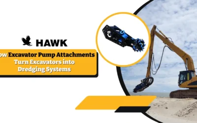
Excavator pump attachments turn standard excavators into dredging systems by using the machine’s hydraulic power to drive a submersible slurry pump....
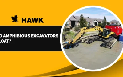
Yes – amphibious excavators can float, but not in the same way a boat operates in open water. These machines are built to work in wetlands,...